

Oak Hill, WV (WOAY-TV) – Based on significant viewer inquiries about the outlook for February, we have sifted through the data to put together our thoughts.
The entire winter, except for Christmas, has been dominated by a La Nina pattern. This is the cooling of the equatorial Pacific that leads to an enhanced Pacific jet stream. The La Nina pattern typically brings storm systems across the U.S. that track through the Ohio Valley or Midwest.
The result (which we have seen on multiple occasions) is front end rain ahead of each system and then more seasonable temperatures and snow showers on the backside of these systems. During this pattern, a persistent high pressure sits off the Southeast U.S. coast and pushes warmer air into southern West Virginia.
An early February cold outbreak will push into the West and then cross the country into southern West Virginia. February 1-4 will bring below average temperatures to southern West Virginia. This means high temperatures cooler than the lower 40s and overnight temperatures colder than the lower 20s. We’ll also have light snow accumulation with systems passing to our south.
Historical matching analogs (previous dates with a similar matching weather pattern) indicate a good chance for several inches of snow accumulation, but not a blockbuster storm (more than 10 inches of accumulation) that leads to serious travel problems.
The cold pattern will be transient though; by February 6-8, temperatures will be off to the races as the cold blast pushes into the North Atlantic and then off towards Europe. We expect high temperatures on February 6 to reach well into the 60s with a good chance for rain.
The Southeast high pressure will flex its muscle and expand north through most of the remainder of February. This same high pressure has been responsible for the tenth warmest winter on record (so far) in Beckley and 18th warmest winter on record in Bluefield. Only transient blasts of seasonable readings and an occasional snow shower or flurry will occur behind frontal systems. Meanwhile, the Rockies and Mountain West will get back into a snowy pattern.
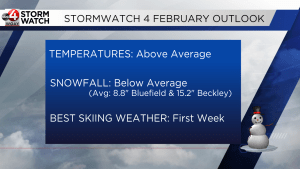
There are signs for another transient cold outbreak at the tail end of the month that would bring a threat for more snow. If this is delayed, it could mean March “comes in like a lion and out like a lamb.” We’ll continue to follow the pattern and bring you updates!


