

We have seen a mix of sun and clouds around the area this afternoon, and there have been some widely scattered showers. There could be more rain as we go through the rest of the evening before fading away after sunset. Where we’ve seen some rain, patchy fog is possible but other areas could see it as well. Lows tonight will be in the lower to middle 60s, pretty close to where they should be.

Tomorrow, the rain chances will go up a bit as the day/night shower and storm pattern continues. There is still a good amount of moisture to work with (dewpoints have been in the 60s today and will be in that neighborhood again tomorrow), and with some weak middle level disturbances coming through the region, the showers and storms will develop during the afternoon in greater numbers than what we saw today.

That trend that continues into the middle of the week as another front will push into the region on Wednesday, pushing the rain chances into the likely category.

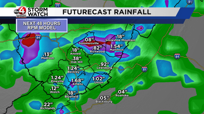
Some of the atmospheric models that we use are showing some impressive rain totals, which makes sense given the amount of moisture, but as usual it all depends on where the showers and storms form. If it’s over the same areas for a couple of days running there could be some issues with ponding water and standing water in low lying spots.
Later in the forecast, the chance for rain decreases as the front moves to our south and washes out. In its wake, high pressure takes over. With the high parked over top of the area, expect temperatures to climb into the upper 80s in most areas, with lower 90s in the usual warmer spots. Heat Advisory criteria (heat indices over 100 degrees) are unlikely to be met, but it will feel uncomfortable if you’re outside. Be sure to take caution.

Beyond the extended forecast, we’ll be closely monitoring what happens with what is now Tropical Storm Erin in the far eastern Atlantic. Stay tuned.

For the video version of the forecast, be sure to copy and paste the link below into your browser…
https://youtu.be/1h8buUSOomI
Sponsored Content



