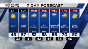
Oak Hill, WV (WOAY-TV): Snow showers will linger for a time tonight and as pavement temperatures chill, watch out for standing water to become black ice tonight.
The colder pattern will only be transient, with a milder trend on tap. There will be a period of rain with a fast Pacific jet stream early next week, but the flooding risk is low. The storm systems will likely not tap into the Gulf of Mexico and bring upside potential for repeated heavy rain similar to what transpired with the most recent frontal system.

Below are the rainfall totals from the last 24-hours and a montage of flood photos collected from viewers and social media followers. It’s best to turn around when you see a flooded roadway as the water is deeper than it appears. One foot of water can float a vehicle.
Rainfall Totals
| Pocahontas County | |
| Hillsboro | 3.24″ |
| Snowshoe | 2.2″ |
| Cass | 1.98″ |
| Marlinton | 1.7″ |
| Raleigh County | |
| Beckley | 3.47″ |
| Beckley (Turnpike) | 2.97″ |
| Ghent | 2.66″ |
| Cool Ridge | 2.57″ |
| Beckley Airport | 2.48″ |
| Ghent (Turnpike) | 2.42″ |
| Cool Ridge | 2.39″ |
| Grandview | 2.29″ |
| Flat Top | 1.93″ |
| Bluefield | 1.5″ |
Flood footage:


