


Oak Hill, WV (WOAY-TV): February will go down in the record books as the second warmest on record in Beckley, just behind 2018, and the third warmest on record in Bluefield just behind 1990.
The weather this afternoon only added to the very warm winter we’ve been experiencing. Check out afternoon temperatures below.

A major pattern shift coming up will deliver cold and likely snow to our region. You may recall our story on a Stratospheric Warming Event, (Polar Vortex Set To Be Disrupted: How Will It Impact Our Weather? – WOAY-TV), which started in mid-February. The second part of that warming is occurring this week. While not all Stratospheric Warming Events impact our weather, there is increasing confidence this season’s warming event will produce a big change in the pattern, starting around March 9.
While the image below probably looks Greek to many, what it’s showing is significant pressure anomalies working down through the Stratosphere (where the warming event occurred) into the Troposphere (where our weather occurs) around March 9. Historically, a warming event and very weak polar vortex dislodges cold temperatures into the Northern Hemisphere.

Another supporting factor for a rapid change to winter in March is the Madden-Julian Oscillation. This pattern is simply a diagram showing where thunderstorms and rain closer to the equator are expected to develop and impact the jet stream winds.

Historically, a strong Phase 8, which all the data indicates will occur by March 9-12, delivers cold weather to southern West Virginia.

Now, we have two pieces of supporting evidence for the cold weather to translate from the Western U.S. to our region.
A third supporting piece of evidence it the strong negative East Pacific Oscillation that will develop early in March. The more negative the pattern, the better chance that cold air pours straight out of Alaska into the Central and Eastern U.S.

So, what should we expect in southern West Virginia? The storm track leading up to March 9 will favor rain, breezy winds and warm weather. After March 9 and likely through March 20-21 (first day of spring), a sustainable cold pattern is expected. Heating bills will be significantly higher in March than any month so far this winter since the cold outbreaks we had early in February and in late December were fleeting and only lasted a few days.
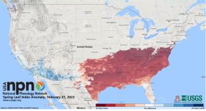
Here is the other problem. Spring has arrived here in southern West Virginia about two weeks ahead of schedule, according to the U.S. Phenology Network, and many of you are seeing flowers bloom. The cold blast will be detrimental to the much earlier start to the growing season. We strongly advise to cover flowers and plants with a blanket during the cold blast to keep permanent cold damage from occurring.
What about snow? A strong match to the upcoming month is March 2005. Bluefield accumulated 20 inches of snow and Beckley tallied 14.7 inches. Beckley averages 8.9 inches in March and Bluefield 6.5 inches, so snowfall far exceeded average. It’s important to note that the pattern doesn’t support one major blockbuster storm but rather occasional periods of accumulation that will add up over time and likely exceed average.
The long story short is that while we will make up for lost snow this winter in March, we won’t completely recover from our winter deficit. The other takeaway is the cold weather will negatively impact the near-record early growing season start, so residents are strongly advised to cover flowers with a blanket through the cold spell and try as best as you can to prevent permanent cold weather damage.
Stay tuned with your StormWatch 4 Team to see what late March through April has in store.


