


WOAY-TV (Oak Hill, WV): A waterlogged system will help alleviate the recent dryness, but there’s more than just rain in the mix.

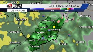
TONIGHT: The first drops of rain will fall by daybreak Tuesday. Freezing drizzle is likely in the western Greenbrier Valley and Pocahontas County, but ice is not expected on roadways. It will be evident on windshields and tree branches, but only a trace to maybe one or two hundredths of an inch will accumulate on those surfaces in the western Greenbrier Valley.
TUESDAY: Rain will become steady during the day and taper off in the evening. Freezing drizzle will change to all rain no later than 9 a.m. in Pocahontas County. Above 3,500 feet is where up to one-tenth of an inch of ice is likely, but even that will melt by late-morning.


A total of 1.0 inch of rain is expected (this will greatly help crews fighting the Steep Valley Fire). Breezy to occasionally gusty winds likely, with highest gusts occurring between 9 a.m. and 5 p.m. Sustained winds of 15-25 mph will be accompanied by gusts of 25-30 mph in the valleys and 35-40 mph gusts on the ridges. Isolated to widely scattered power outages are possible at the highest elevations. The National Weather Service has issued a wind advisory.


Dense fog will develop in the western Greenbrier Valley on Tuesday and likely not dissipate until Wednesday morning, so prepare for visibility to drop to a quarter mile along the eastern facing slopes of the valley.
WEDNESDAY: Fog will lift in the Greenbrier Valley and clouds will increase aloft, but no precipitation is expected. West of the Greenbrier Valley expect mostly cloudy skies and dry weather.
THANKSGIVING DAY: Mostly sunny and mild.


